 Lehigh River
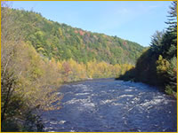
The Lehigh River begins in the marshes and bogs of the Pocono Mountains near the town of Goldsboro. The elevation of the marsh headwater area is 2,200 feet above sea level and the river drops approximately 1,000 feet during the 100 mile journey to the Delaware River in Easton, Pennsylvania. The Lehigh River watershed is 1,360 square miles and is part of the Delaware River watershed.
Lehigh River History
During the 1800s the Lehigh River was an important waterway that enabled the Lehigh Valley to transport coal, lumber and cement to the Philadelphia region. The Lehigh was once privately owned by the Lehigh Coal and Navigation Company making it the only privately owned river in the United States. Portland cement was manufactured along the banks of the Lehigh in the town of Coplay and a Bethlehem Steel plant was also located along the Lehigh River. The forests that lined the banks of the Upper Lehigh River helped establish Pennsylvania as one of the greatest lumber producing states in during the 1800s.
The Lehigh River Today
The river is as important to the Lehigh Valley region today as it was in the 1800s, but with its scenery, whitewater excitement and historical value, the Lehigh is now as a recreational and tourism attraction for outdoor enthusiasts and history enthusiasts. And there are special geographical features of the area which make it a great area for wildlife viewing. One feature is the physical layout of the Blue Mountains which traffic the raptor migration routes over the Lehigh River at Lehigh Gap. So while you are paddling through this section look for hawks, eagles, osprey. You will also have a good chance of seeing great blue heron, marganser, wood duck, kingfisher and warblers. Other wildlife you may encounter are blackbear, rattlesnakes, turkey, deer, river otter, beaver and muskrat. As far as fishing goes, the Lehigh River supports smallmouth bass, trout, and muskellunge. The Lehigh is stocked with trout from White Haven to Jim Thorpe every year.
 Lehigh River Water Trail
The Lehigh River Water Trail is 72 miles long beginning at White Haven and ending at the confluence with the Delaware River in Easton. The water trail is comprised of the northern and southern sections and provides plenty of canoeing, kayaking and rafting opportunity in a variety of fast exciting rapids or slow leisurely excursions.
Northern Section
This 41 mile section begins in White Haven and ends at the Lehigh Gap at Blue Mountain. This section of the Lehigh River runs through the Lehigh Gorge State Park and is known to have some of the most exciting whitewater in the east, along with some very beautifully carved gorges. This section has class two and three rapids and requires whitewater canoeing or kayaking experience. All open canoes must be outfitted with floatation in this section.
Southern Section
This 31 mile section begins at Lehigh Gap at Blue Mountain and ends at the Lehigh and Delaware River confluence in Easton. This section is wider and slower than the northern section and is more appropriate for leisurely paddling or entry level whitewater. There are multiple access points on this section that can be accessed in Allentown, Bethleham and Easton. See the links at the bottom of the page for Lehigh River maps.
Canoeing and Kayaking the Lehigh River
The Lehigh River is one of the most popular class 3 canoeing and kayaking destinations in Pennsylvania and is considered by some to be the training waters for future class 4-5 kayakers. The northern section through the Lehigh Gorge State Park is bustling with activity in the spring and during scheduled dam releases throughout the summer. There is plenty of access to this river allowing you to begin your paddling trip below the Francis E. Walter Dam, Whitehaven, Rockport or Glen Onoko. But the 12 mile paddle from Rockport to Glen Onoko is one of the most scenic and popular sections of the river for thrill seeking paddlers.
Rockport is a very popular destination for nature lovers so expect to encounter groups of paddlers, hikers fisherman and mountain bikers on the weekends. During the week you might have the river to yourself.
Glen Onoko is also a favorite destination among the locals and tourists. It’s a great point to take a break from your paddling because it’s here where you will find the Glen Onoko Falls, and it is worth taking an hour to make the climb to the top of the falls. There are bathroom and changing facilities at Rockport and Glen Onoko.
Camping is not permitted on this section of the river but commercial camping is available at the nearby Hickory Run State Park (570-443-0400), and the Mauch Chunk Lake Park in Jim Thorpe (570-325-3669), and the Jim Thorpe Camping Resort (570-325-2644).
Lehigh River water levels often depend on scheduled releases from the Francis E Walter Dam so be sure to check the water levels before planning your trip. Flows ranging from 250 to 1,000 cubic feet per second are best for most types of boating. At flows above 1,000 cubic feet per second the level of difficulty becomes progressively greater and requires higher levels of whitwater skills.
Download the Northern Section and the southern section PDF maps from the Fish and Boat Commission Website.

