

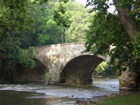
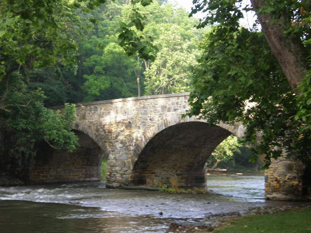
Burnside's Bridge
Antietam Creek, located in Washington County, is a tributary of the Potomac River and is one of Maryland’s most popular paddling creeks. The West and East Branches of the Antietam Creek are formed near Waynesboro, Pennsylvania but the main canoeable section of the Antietam Creek is near Sharpsburg, Maryland. The creek is separated into the upper and lower sections by a dam at Devil’s Backbone County Park. This content covers the lower section of Antietam Creek beginning at Devil’s Backbone County Park and ending at the Potomac River.
The Antietam is mostly fed by ground water and is canoeable almost year round. Minumum level for the lower Antietam is 2.6 ft, but at this level you will definately be scraping and dragging your boat as our group of kayakers and canoers did during our June 2007 trip. In the future I’ll consider anything below 3.0 ft inadequate for paddling the lower Antietam.
Antietam Battlefield History
People choose to paddle a location for a variety of reasons such as scenery, serenity, challenge, fishing or even camping. But for some people there might be a different reason to paddle the Antietam Creek. Although it offers the fishing, scenery and some class 1 paddling challenge, what the creek really offers is an opportunity to paddle through the famous Antietam Civil War Battlefield. It was on September, 17 1862 that Union General McClelland launched an attack on General Robert E. Lee along the Antietam Creek near Sharpsburg, Maryland. This battle was the first Civil War Battle fought in northern territory and the most bloody single day battle during the Civil War. During this battle it was the famous event at Burnside’s Bridge where a small number of Confederate soldiers held off thousands of Union soldiers led by General Ambrose Burnside. While paddling the lower Antietam you’ll paddle through a section of the Antietam Battlefield and under the famous Burnside’s Bridge.
 The Lower Antietam
The lower section of the Antietam is the most popular section, and for good reason. On this lower section you will experience great scenery, slow sections, fast flowing sections with sharp turns and challenging currents created by a confluence of slow and swift moving water. There are obstacles such as rocks, bridges, riffles, drops, and yes, strainers. These strainers could be a dangerous hazard during high water levels.
Soon after your launch at the Devil’s Backbone County Park your challenge will begin. During low water levels you’ll encounter deceptive current speeds that will make perfect targets of the rocks ahead of you. You’ll also encounter slight drops and staircases of rocks that could stop your boat in one of those awkward swift current situations. You might encounter deceptive current easily capable of casting you overboard. I humbly speak of this from personal experience. And near the end of the trip there is a short class 2 section called Furnace Rapid just before entering the Potomac. Furnace Rapid is not too challenging but takes maneuvering skills during lower water conditions. During higher water conditions you would probably paddle over the rocks. Also during the first few miles of our trip we encountered several fisherman, and one with some attitude. The creek is very narrow in places but do your best to give fisherman as much space as possible.
Warning! – Even though the majority of this creek is class 1 and slow moving in sections, don’t take it lightly. At the launch of our trip one of the locals warned us of the swift current, and his warning was warranted as I dumped my canoe on a few occasions.
 Trip Distance and Time
Paddling the lower Antietam is a short trip of approximately 12 miles or less depending on where you take out. Your only launch option is at Devil’s Backbone County Park on Route 68 near Sharpsburg, but you can choose between two takeouts. The first takeout is the Burnside Bridge takeout just below the actual historical Burnside Bridge. (Warning! It is illegal to dock at the actual Historical Burnside Bridge in the Antietam Battlefield). The other option, which I recommend, is the Potomac River takeout. Paddling from Devil’s Backbone to the Potomac can take four to six hours depending on your ambition. It took us four hours and we didn’t work hard. Althought there are some very slow spots in sections, the majority of time the current seemed to carry us along at a decent three to four miles per hour. Shuttling vehicles isn’t bad either. It should take about an hour. During your shuttle you can drive down the Sharpsburg Pike (Route 65) to the Harpers Ferry Road, or you can drive through the country on Wheeler Road and Route 34. Here is a link to an Antietam Creek map.